

Tuesday, July 29, 2008


Shockingly Voluminous (Once Dreaded) Rim Gravel, redux
Alas, brother spud, unless we are on different conceptual planes here, the paper in question does not directly address the SV(OD)RG. Instead, it is focused on the fluvial sediments in the middle Miocene part of the section, specifically the arkosic sandstone and mudstones that we see interbedded with rhyolite just downstream from AM-PM camp:


In the context of our studies, this part of the record is only a glimpse into an ancient precursor drainage system. In fact, I think that a fair amount of the SV(OD)RG in our study area is related to lava damming events in the latest(?) Miocene and into the Pliocene (i.e. the Bogus Rim).Thus, is is possible that the SV(OD)RG represent blockage of an integrated / partially integrated Owyhee. Recall that the base of the Bogus lava sits on river gravel in various places between Iron Point and Birch Creek. I suspect it was the blockage of this system in the early Pliocene to late Miocene(?) that deposited the gravels that form a flat surface at 3900'. Subsequent and possibly sporadic incision through the gravel cover after the breach formed several discernible levels of gravel. This is directly analogous to the distribution of the much less widespread and voluminous gravels above the Quaternary blockages. It is that latter point that really pulls me in. Any counter arguments? Anyone?
In the figure below, I have pointed out some features of the gravel. I have approximated its MINIMUM extent using the snow-like pattern. Have also noted the problem with the Ice Axe as Bogus Rim (stay tuned for explanatory post on that one). This is a crude mock-up. A more formal figure will be forthcoming with lots of elevation data...(just got me a Trimble XH...arrived today!).


In the context of our studies, this part of the record is only a glimpse into an ancient precursor drainage system. In fact, I think that a fair amount of the SV(OD)RG in our study area is related to lava damming events in the latest(?) Miocene and into the Pliocene (i.e. the Bogus Rim).Thus, is is possible that the SV(OD)RG represent blockage of an integrated / partially integrated Owyhee. Recall that the base of the Bogus lava sits on river gravel in various places between Iron Point and Birch Creek. I suspect it was the blockage of this system in the early Pliocene to late Miocene(?) that deposited the gravels that form a flat surface at 3900'. Subsequent and possibly sporadic incision through the gravel cover after the breach formed several discernible levels of gravel. This is directly analogous to the distribution of the much less widespread and voluminous gravels above the Quaternary blockages. It is that latter point that really pulls me in. Any counter arguments? Anyone?
In the figure below, I have pointed out some features of the gravel. I have approximated its MINIMUM extent using the snow-like pattern. Have also noted the problem with the Ice Axe as Bogus Rim (stay tuned for explanatory post on that one). This is a crude mock-up. A more formal figure will be forthcoming with lots of elevation data...(just got me a Trimble XH...arrived today!).

(click on image for full size)
Monday, July 28, 2008
Reference related to the "Shockingly Voluminous" Rim Gravel
Hi Folks:
Here is a reference from my thesis that a very nice man (who once offered me a job in mineral exploration) turned me on to:
Here is a reference from my thesis that a very nice man (who once offered me a job in mineral exploration) turned me on to:
Rytuba, James J., and Vander Meulen, Dean B., 1991, Hot-Spring PreciousIf I remember correctly, I think it is pretty relevant to the dreadfully voluminous rim gravel and provides some corroboration of some of the things Dr. Jerque and others are finding in the field. Dr. Jerque may have a copy and I can scan you a copy sometime if you can't find it.
Metal Systems in the Lake Owyhee Volcanic Field, Oregon-Idaho;
in Raines, G.L., et al., 1991, Geology and Ore Deposits of the Great Basin,
Symposium Proceedings, USGS and Geological Society Nevada, Reno, Nevada,
Volume II, pp. 1085-1096.
Monday, July 21, 2008
Traverse Map, PKH, July 2008

Sunday, July 20, 2008
Summer 2008 on the Owyhee, Part 1
Spent all of last week on the Owyhee. Many rim hikes and a few forays down to the wet stuff. The latter with Liz and her students. Learned alot. Found a fault in Sweetwater Canyon (that between Jordan Creek and Hike-out Camp). Determined that the once 'dreaded' rim gravels are really the 'shockingly voluminous' rim gravels. As for the latter, there appears to be a culmination of aggradation on a platform at about 3900'. Multiple levels are present below this, mainly on the Artillery Rim. Found a tephra in a rare exposed section at the 3900' level near Owyhee Butte. Learned that the Heaven's Gate landslide complex (including an upper reach and a lower reach) is quite huge, particulary when viewed from the perspective of the canyon rim...wow. Can't imagine how this complex was not the source of multiple blockages and breaches. Liz nearly single-handedly augered a 4 m hole in a perfect closed depression. We found the Mazama, and certainly drilled into the late Pleistocene...but didn't find the fat tephra bed that we found in the slide below Bogus Point. For now, please view the following slide show for substantiation of most of the claims above (view in Google Maps or Google Earth for the full informative effect):
Tuesday, June 10, 2008
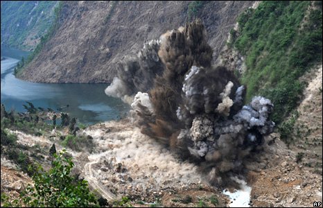
Chinese Landslide Dam Failure Flood in Action
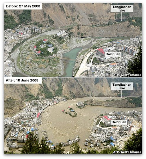 This photo pair is interesting. Amazing how close the community is to the landslide dam...it so easily could have been partly buried by the landslide...but in that case, maybe the valley could not have been dammed so easily. Moot, obviously.
Monday, June 9, 2008
Landslide Dam Failure in China

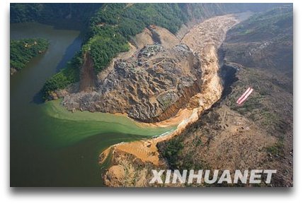
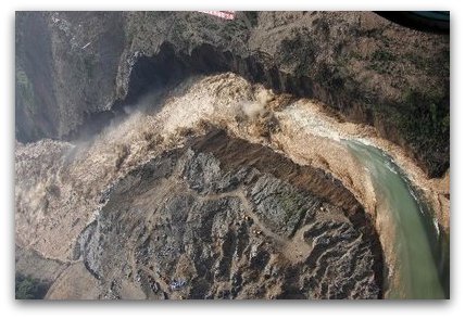 The significance of these photos to the average Yeehow is quite clear. The principal landslide dam following the recent major earthquake in China has failed. These photos show the breach and the incredibly cool draw-down tongue. For some cogent discussion about this event, check out the blog of Dr. David Petley at which I found the bottom two images and a lot of commentary: http://daveslandslideblog.blogspot.com/
Tuesday, June 3, 2008
Damming Ruminations by Brother Spud
Hi Folks,
Here are the figures from my thesis that relate to the last post I made on friday night. I hope they help you visualize some of what I described.
-Spud
 Figure 2. Exposure of the Saddle Butte lava near Read-it-and-Weep rapid (river kilometer 34.25). Exposure shows foreset beds of hyaloclastite and lava pillows, the passage zone, and subaerial lava. The foreset beds of pillow lavas and hyaloclastite dip down to the right, indicating that the lava advanced from left to right into a body of standing water. Much of the hyaloclastite has altered to orange-colored palagonite. The passage zone marks the elevation of the water surface. Above the passage zone, subaerial lava was emplaced. Exposure is ~60 m thick.


Here are the figures from my thesis that relate to the last post I made on friday night. I hope they help you visualize some of what I described.
-Spud
 Figure 2. Exposure of the Saddle Butte lava near Read-it-and-Weep rapid (river kilometer 34.25). Exposure shows foreset beds of hyaloclastite and lava pillows, the passage zone, and subaerial lava. The foreset beds of pillow lavas and hyaloclastite dip down to the right, indicating that the lava advanced from left to right into a body of standing water. Much of the hyaloclastite has altered to orange-colored palagonite. The passage zone marks the elevation of the water surface. Above the passage zone, subaerial lava was emplaced. Exposure is ~60 m thick.
Figure 15. Aerial photograph of river kilometers 37.5–39.5 showing presumed initial location of West Crater lava dam. The

Figure 16. Photograph of outcrop relations at river kilometer 39.25. The Saddle Butte lava appears to underlie the sediment lens in the center of the photograph. The head of the West Crater lava dam overlies the sediment lens and the Saddle Butte lava. Foreset beds of pillow lavas and hyaloclastite dip down to the right in this image. Several different passage zones (indicated by PZ) indicate the lake level rose during construction of the dam. The location of the paleovalley wall discussed in Figure 15 is indicated by a dashed ellipse. The lens of sediment interpreted to be paleo-Ryegrass Creek is visible in the center of the photograph.
Friday, May 30, 2008
Speculations and Declarations from the Spud
Oooohh Boy, Here are some ramblings for you to chew on, some of which I have been chewing on for some time (years). Dr. Jerque’s previous comments are in italics. Sorry to post a dry reply without any figures--I am having trouble pulling them into the blog--will try on Sunday. Figures 2, 15, and 16 are pretty relevant to the discussion.
The upper West Crater lava in the presumed abutment on river right does not have lava-delta deposits (wtf?). In the field, it looks like a dry flow. Why would water have not backed up in this area during the blockage? The contact of young WC on Old WC marks the perimeter of the 3400 ft lake. I suppose this part could have been dry initially as the flow continued in a generally downstream direction....
Yes, the youngest WC (above the 3400 ft contour) does not appear to have any evidence of lava-water interaction. But, the uppermost flow units immediately below 3380 ft surface do transition quickly (within a few meters) into a lava pillow delta via a passage zone (see Figure 2 in my thesis). I can think of at least two options for why the lava above the 3400 ft contour doesn’t have any pillows: 1) Lava was entering the river canyon at a much faster rate than the river discharge (and the rate of lake rise) such that the lava dam growth outpaced the rise of the reservoir; 2) the level of the reservoir stabilized at ~3370 ft (perhaps because a stable spillway developed adjacent to Pruitt’s Castle or because the dam was porous). In either case, if the full discharge of the river could seep through or sneak around the dam, the crest of the dam could grow uninhibited and not be within the reach of the water.
Option 1 is complicated by the fact that we know that the rate of dam construction and lake level rise was semi-episodic because of the presence of multiple passage zones (and accompanying subaerial lava) preserved within the dam.
In regards to Dr. Jerque’s questions about the timing of individual incursions of lava into the river and the total lifespan of the obstruction created, I think the dams are built quickly. The vents supplying lava to the intracanyon lava flows are monogenetic and probably have a life span of months, years, or perhaps tens of years, but not hundreds of years. From my understanding of Snake River Plain volcanism and the experience of those such as our p-mag expert, these lava flows could easily erupt, flow across the uplands, and build a dam in a few months or maybe several years. During that time, individual pulses of lava (flow units, cooling units, surges, etc.) added to the obstructions created by the first lavas in a tug of war battle with the rising lakes. The multiple (and rising in elevation) passage zones at Weeping Wall and WC at tell us this. The resulting dam is so geologically instantaneous that it makes sense to me to model it mostly as a single event. The details of the passage zone elevations, relative amounts of subaerial vs subaqueous lava, and volume of hyaloclastite tell us some of the juicy details of the event but in terms of the ~2 Ma history of the river available to us to model I would consider it one event. Even in the case of the SB dam, where there are two clearly different advances into the canyon (that potentially could be separated by a lot of time) we do nto see any different in age with the p-mag. We also do not see any fluvial deposits intercalated within the dam architecture that would suggest a long time interval (1000s to 10000s of years). What do you think?
One of my thesis’ objectives was to try to add data to, and refine, lava dam emplacement and breaching models (and the associated hazards) by trying to study how the rate of lava effusion into a river interacts with the river’s discharge and channel morphology to influence the structure and stability of lava dams. This objective was often overshadowed by the larger objective of just trying to figure out what he-ack is going on out there and distinguish the lava flows from one another but I do think that there is enough data to address the matter in the paper I am putting together on the lava flows.
Cheers,
Spud
Wednesday, May 28, 2008
Lava-dammed lakes in Owyhee Canyon
 Here is a thought-provoking image that I created in Global Mapper this evening (click on it to enlarge). It shows the extent of a dam with a crest elevation of 3400 feet, which is the approximate elevation of the Saddle Butte 2 and West Crater Lava Dams (right, I couldn't get the blue from extending downstream, but you get the point). I have sketched in some likely dam locations...the Saddle Butte Dam is obvious because both abutments still exist. The West Crater dam, however, is a little harder to guess. The right (east) abutment is pretty obvious, but the left (west) one is not. In both cases, as we know, Rome Valley was inundated. Duh (in hindsight)
Other points:
The upper West Crater lava in the presumed abutment on river right does not have lava-delta deposits (wtf?). In the field, it looks like a dry flow. Why would water have not backed up in this area during the blockage? The contact of young WC on Old WC marks the perimeter of the 3400 ft lake. I suppose this part could have been dry initially as the flow continued in a generally downstream direction....
In the case of each dam, the damming event that is most well preserved 'immediately' post-dates an intracanyon flow from the same vent. We don't have any direct evidence that these flows dammed the river...but they certainly may have, or did they? wtf?
Is it of any interest to the modeling and general conceptualization of the processes that the lava events that clearly dammed the river were damming a river that may still have been in the process of dealing with the previous lava incursion from the same vent? (thus not so long ago, relative to the damming event).
Any thoughts? Break down and post some comments or, maybe, your own diagram....
Tuesday, May 13, 2008
First view of Geologic Map in Google Earth

Ok. So I recently learned that ESRI actually provides a kml-making tool in the toolbox. That is handy. I haven't yet figured out how to create a clean version to distribute, but this screen shot should provide some perspective on where this can go.
Wednesday, May 7, 2008
Shaded Relief Revelations
 I used Globalmapper (more on that later) to quickly create this shaded relief image of the study area. Are most of the lava platforms that are so evident in this image related to lava-dams? The various volcanic structural forms in this image are really very striking. If it turns out that all or most of these features reflect late Neogene lava-water interaction, this is a fairly significant landscape-forming process in this region...the distribution of these features on the landscape record the progressive incision of the Owyhee River over a very long time, no?
Sunday, May 4, 2008
Traverse Documentation via Garmin 60csx and Topofusion

Friday, May 2, 2008
First Glance at Fully Geotagged Photos From Recent Trip
The embedded slideshow below includes all of the photos that I took on the trip. They are all geotagged and it is very cool to view them on the map (click 'view map'). Zoom in in terrain mode and have at it. Be sure to check out the areas most far flung from the river...or anywhere that you didn't go. I will eventually trim this collection down and add some captions. Sorry, very few people pictures.
Rare Sighting of Yeehow in Spring Plumage
It is not every day that you have a chance to see a Yeehow in this condition of 'dress'. I have taken a step away from the scientific focus of the blog to share this spectacularly rare image:


Thursday, April 10, 2008
Align your mind with the Owyhee...Spend some time with this slideshow.
Preparing for the upcoming trip? This will help align your mind. Most of these photos are from the rim or, at least, off the river. I certainly love river trips, but the geologic context of the study area is best appreciated from above.
The slides below can be viewed in relation to a map of where the photos were taken because they are geotagged. Just click on a slide and your browser should open up the online photo album. Click on view album map to see where the photos were taken. Zoom in and notice that Google Maps now includes contours in terrain view. That is cool. Click on view in Google Earth and learn a little more about where the photos were taken.
The slides below can be viewed in relation to a map of where the photos were taken because they are geotagged. Just click on a slide and your browser should open up the online photo album. Click on view album map to see where the photos were taken. Zoom in and notice that Google Maps now includes contours in terrain view. That is cool. Click on view in Google Earth and learn a little more about where the photos were taken.
Friday, March 28, 2008
Caving in on the Owyhee...A public service announcment

Accept the fact that you also need to cave in and send your slides to a similar place so that you can actually view them, organize them, remember them, etc. Your slides are just getting older and older. One day they will mean very little to you. Digitize them now. You will be very happy with the results.

Thursday, March 27, 2008
Owyhee Research at GSA in Vegas
| Cordilleran Section (104th Annual) and Rocky Mountain Section (60th Annual) Joint Meeting (19–21 March 2008) | |
| Paper No. 1-9 | |
| Presentation Time: 11:00 AM-11:20 AM | ||
QUATERNARY BASALTIC VOLCANISM ALONG THE NORTHWESTERN MARGIN OF THE OWYHEE PLATEAU, SE OREGON | ||
| SHORT, Emily J., JASTRAB, Jamie M., and HART, William K., Geology, Miami University, 114 Shideler Hall, Oxford, OH 45056, shorte@muohio.edu The Owyhee Plateau tectonomagmatic province is located in the Oregon-Idaho-Nevada border region and preserves evidence of complex magmatic processes and mantle reservoir interactions over the past 17 Ma. Quaternary basaltic volcanism is concentrated along the northern and northwestern margins of the Plateau in a number of discrete to overlapping volcanic fields characterized by monogenetic cones and small shields. The focus of this investigation is three young basalt volcano fields, the Saddle Butte field (SdB), Jackie's Butte field (JB), and Scott's Butte field (ScB), that lie near the suggested physical northwestern edge of the Owyhee Plateau. In contrast to the multiple monogenetic shield vents of the SdB and the JB, the ScB is dominated by a single vent complex (Scott's Butte) that preserves evidence of early hydrovolcanic activity followed by emergent central and satellite vent Strombolian and Hawaiian activity. New stratigraphic observations and preexisting K-Ar data, when viewed in the context of more extensive chronologic data for the nearby Jordan Valley volcanic field (JVVF), indicate that the volcanism considered in this investigation is less than approximately 1.2 Ma, with portions of the Saddle Butte field likely less than 100 ka in age. Furthermore, stratigraphic relationships along the Owyhee River canyon document the presence of flows likely emanating from 1.9 Ma and older JVVF vents stratigraphically beneath eruptive products of the SdB. Between volcanic field and between vent major and trace element variability is observed including little fractionated, LIL and HFS element depleted olivine tholeiites (HAOT) in the SdB and JB, basalts with characteristics in common with certain Snake River olivine tholeiites (SROT) and young JVVF alkaline basalts in the JB, and basalts transitional to these varieties in the ScB. Within vent geochemical heterogeneities also are observed, only some of which may be produced via shallow fractional crystallization and/or small differences in degree of melting. The observed geochemical complexities require the presence of heterogeneous lithospheric mantle and lower crustal reservoirs beneath this region and post magma generation differentiation processes that involve mixing of heterogeneous melts and/or melts and solids derived from these reservoirs. | ||
| Cordilleran Section (104th Annual) and Rocky Mountain Section (60th Annual) Joint Meeting (19–21 March 2008) General Information for this Meeting | ||
| Session No. 1 Igneous/Metamorphic Petrology, and Volcanology University of Nevada-Las Vegas: Student Union 208C 8:00 AM-12:00 PM, Wednesday, 19 March 2008 Geological Society of America Abstracts with Programs, Vol. 40, No. 1, p. 34 | ||
© Copyright 2008 The Geological Society of America (GSA), all rights reserved. Permission is hereby granted to the author(s) of this abstract to reproduce and distribute it freely, for noncommercial purposes. Permission is hereby granted to any individual scientist to download a single copy of this electronic file and reproduce up to 20 paper copies for noncommercial purposes advancing science and education, including classroom use, providing all reproductions include the complete content shown here, including the author information. All other forms of reproduction and/or transmittal are prohibited without written permission from GSA Copyright Permissions. | ||
Tuesday, March 4, 2008
Yeehoogle Earth

While procrastinating on some very important things today, I taught myself how to make an attractive and viable Google Earth layer that highlights geology. I started doing it to accompany a map and related text in southern Nevada, and then remembered that I claimed that I would produce this type of thing (with help!) for the Owyhee project.
I did this with a lot of help from Google who have recently created a spreadsheet template (using Google Docs) that makes this a pretty painless process. I thought it would be hard until I watched a 5-minute tutorial.
I can't post a file on Blogger, so I will be sending each of you a kmz file for the Owyhee project and a slighly more realized one from the lower Colorado River. If you keep one or both of them in Google Earth (i.e. not in the Temporary Places folder) they will automatically update. If you are truly adventurous, I will share the spreadsheet with you so that you can add things (that means you, Liz...).
Subscribe to:
Posts (Atom)