Sunday, November 22, 2009

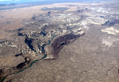
Killer Owyhee Pic of the Week #2


A nice oblique shot of the Saddle Butte and West Crater lava convergence zone. Lots of important features are clear in this one. Look for your favorite!

Friday, November 13, 2009

New and Improved Profile figure and other...

Ignore the mixed units and bask in the glory of a better long-profile:


Today, I learned some very cool techniques for extracting key data from the LiDAR as well as for analyzing and displaying the results in Arc. I had never experimented with the graphing tools in Arc, but Natalia showed me some really interesting applications of them while we rode the train from Portland to Eugene.

I suspect that some of you may be in the know, but I put together an explanation of sorts that includes some interesting data from the Owyhee here:


I didn't finish the lava profiles, but got a good start today. In the field all next week down in Vegas worrying about a different project. Back on Owyhee when I return.

Lyell was a closeted catastrophist?

A recent (re?)-discovery by fellow Yeehow JEO:

Not so fresh geofroth, but insightful nevertheless:

Our historical figure states thusly...

"The power which running water may exert, in the lapse of ages, in widening and deepening a valley, does not so much depend on the volume and velocity of the stream usually flowing in it, as on the number and magnitude of the obstructions which have, at different periods, opposed its free passage."

which follows upon...

"It is evident, therefore, that when we are speculating on the excavating force which running water may have exerted in a particular valley, the most important question is not the volume of the existing stream, nor the present levels of the river-channel, nor the size of the gravel, but the probability of a a succession of floods, at some period since the time when some of the land in question may have been first elevated..."

Who is our extrafluvial catastrophist?

None other than Charles Lyell!

Lyell, C., 1830, The Principles of Geology, vol. i. John Murray, London.
The first quote is from page 192, and refers directly to floods resulting from breached obstructions as key to forming valleys. The second quote is from page 188.

Posted via email from Fresh Geologic Froth

Thursday, November 12, 2009

Sweet Owyhee Pic of the Week


A nearly complete shot of the East Spring (Greeley) landslide. Yowza.

Thursday, November 5, 2009

Short clip of the Owyhee fly-over...

Worth a look. Gives a good impression of what the flight was like. Certainly quicker than a raft.

Posted via email from Arbitrary Frothings

Wednesday, November 4, 2009

Slide Show from Today's Owyhee Fly-over

As promised, here are the pictures. If you would rather seem them on the Picasa site, you can go there with this link:

http://picasaweb.google.com/drjerque/OwyheeFlyOver?feat=directlink

Once there, choose view on map, or grab the kml link for a better overall experience. Note however, that the geotagging is locally off...I wasn't totally prepared to deal with a tracklog derived from a trip in a vehicle that was usually moving more than 150 mph or so. In that case, the clocks need to be tightly calibrated (to the second) and the track precision needs to be high. I will manually fix the egregious ones using the new and nifty interactive geotagging interface in Picasa.

An amazing day in the field...


Today, I had the opportunity to fly over our field area in a spiffy little experimental aircraft with my UNR colleague, Greg Arehart. Greg built the plane and is an accomplished pilot. It was an excellent time. From Reno, it takes less than two hours to reach the Owyhee in his plane. Once there, we followed an improvised flight plan driven largely by my whims and Greg's skills at maneuvering an aircraft. The map below shows the path:


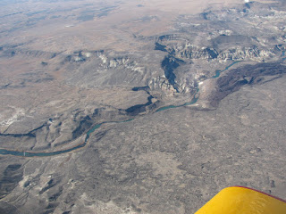
It was mind-bending to be able to see the field area from this vantage. I took around 200 photos from the cockpit. Below is a very nice example. Note that it was a beautiful day to be in the field.


Best of all is the underwing camera that Greg installed on the plane. It is controlled by a laptop computer in the cockpit and takes absolutely amazing vertical air photos with overlap adequate for stereo viewing. The image below should suffice to prove that. I took 190 of these photos.


All of the photos will be posted or otherwise made available soon!

Tuesday, November 3, 2009

Will be visiting the field area tomorrow...in a plane!

Tomorrow I get a chance to fly over the field area in a small plane
fitted with an underwing camera. This was part of the deal that got me
to agree to teach field camp this last summer...and it is finally
coming through. Greg Arehart, my UNR colleague, has offered to fly me
over the area and snap many, many photos with his spiffy camera. These
will be ideal for creating large scale stereopairs of key areas
(failed blockages, landslide dams, etc) and also many great oblique
shots.

Below are some photos Greg took while flying over the field camp site in June.

Posted via email from Fresh Geologic Froth

Flash Earth and Geohacks...Who knew? Not me.

Just happened upon a sweet and simple geobrowser called Flash Earth...very smooth and easy to understand. Added bonus for me is that it links to high-res images of my favorite field area that are available only in Yahoo and Bing Maps:

Seems my pals at Google still just don't care about SE Oregon. Anyway, I found the site by perusing the details in an exif header in one of my geotagged photos. Was checking that out in Irfan View, a program I was aware of but hadn't tried yet. Turns out, it is well worth a look:

Which led me to the GeoHack wiki:

The internets are amazing, no? Totally cool.


Posted via email from Fresh Geologic Froth