Wednesday, December 9, 2009

Owyhee River LiDAR drape on low-res Google Earth images

Ok. So Google is apparently never going to upload the high-res NAIP
imagery of the Owyhee River study area. Here is a work-around. Draping
the LiDAR on the bad imagery. Looks pretty damn good. Now we are very
proficient at doing this. On our way to developing some more elaborate
geologic projects in Google Earth. Should probably start with adding the hi-res imagery ourselves....

Thanks to Heather...she made it to the LiDAR class in San Diego last week!

Posted via email from Fresh Geologic Froth

Sunday, November 22, 2009

Killer Owyhee Pic of the Week #2


A nice oblique shot of the Saddle Butte and West Crater lava convergence zone. Lots of important features are clear in this one. Look for your favorite!

Friday, November 13, 2009

New and Improved Profile figure and other...

Ignore the mixed units and bask in the glory of a better long-profile:


Today, I learned some very cool techniques for extracting key data from the LiDAR as well as for analyzing and displaying the results in Arc. I had never experimented with the graphing tools in Arc, but Natalia showed me some really interesting applications of them while we rode the train from Portland to Eugene.

I suspect that some of you may be in the know, but I put together an explanation of sorts that includes some interesting data from the Owyhee here:


I didn't finish the lava profiles, but got a good start today. In the field all next week down in Vegas worrying about a different project. Back on Owyhee when I return.

Lyell was a closeted catastrophist?

A recent (re?)-discovery by fellow Yeehow JEO:

Not so fresh geofroth, but insightful nevertheless:

Our historical figure states thusly...

"The power which running water may exert, in the lapse of ages, in widening and deepening a valley, does not so much depend on the volume and velocity of the stream usually flowing in it, as on the number and magnitude of the obstructions which have, at different periods, opposed its free passage."

which follows upon...

"It is evident, therefore, that when we are speculating on the excavating force which running water may have exerted in a particular valley, the most important question is not the volume of the existing stream, nor the present levels of the river-channel, nor the size of the gravel, but the probability of a a succession of floods, at some period since the time when some of the land in question may have been first elevated..."

Who is our extrafluvial catastrophist?

None other than Charles Lyell!

Lyell, C., 1830, The Principles of Geology, vol. i. John Murray, London.
The first quote is from page 192, and refers directly to floods resulting from breached obstructions as key to forming valleys. The second quote is from page 188.

Posted via email from Fresh Geologic Froth

Thursday, November 12, 2009

Sweet Owyhee Pic of the Week


A nearly complete shot of the East Spring (Greeley) landslide. Yowza.

Thursday, November 5, 2009

Short clip of the Owyhee fly-over...

Worth a look. Gives a good impression of what the flight was like. Certainly quicker than a raft.

Posted via email from Arbitrary Frothings

Wednesday, November 4, 2009

Slide Show from Today's Owyhee Fly-over

As promised, here are the pictures. If you would rather seem them on the Picasa site, you can go there with this link:

http://picasaweb.google.com/drjerque/OwyheeFlyOver?feat=directlink

Once there, choose view on map, or grab the kml link for a better overall experience. Note however, that the geotagging is locally off...I wasn't totally prepared to deal with a tracklog derived from a trip in a vehicle that was usually moving more than 150 mph or so. In that case, the clocks need to be tightly calibrated (to the second) and the track precision needs to be high. I will manually fix the egregious ones using the new and nifty interactive geotagging interface in Picasa.

An amazing day in the field...


Today, I had the opportunity to fly over our field area in a spiffy little experimental aircraft with my UNR colleague, Greg Arehart. Greg built the plane and is an accomplished pilot. It was an excellent time. From Reno, it takes less than two hours to reach the Owyhee in his plane. Once there, we followed an improvised flight plan driven largely by my whims and Greg's skills at maneuvering an aircraft. The map below shows the path:


It was mind-bending to be able to see the field area from this vantage. I took around 200 photos from the cockpit. Below is a very nice example. Note that it was a beautiful day to be in the field.


Best of all is the underwing camera that Greg installed on the plane. It is controlled by a laptop computer in the cockpit and takes absolutely amazing vertical air photos with overlap adequate for stereo viewing. The image below should suffice to prove that. I took 190 of these photos.


All of the photos will be posted or otherwise made available soon!

Tuesday, November 3, 2009

Will be visiting the field area tomorrow...in a plane!

Tomorrow I get a chance to fly over the field area in a small plane
fitted with an underwing camera. This was part of the deal that got me
to agree to teach field camp this last summer...and it is finally
coming through. Greg Arehart, my UNR colleague, has offered to fly me
over the area and snap many, many photos with his spiffy camera. These
will be ideal for creating large scale stereopairs of key areas
(failed blockages, landslide dams, etc) and also many great oblique
shots.

Below are some photos Greg took while flying over the field camp site in June.

Posted via email from Fresh Geologic Froth

Flash Earth and Geohacks...Who knew? Not me.

Just happened upon a sweet and simple geobrowser called Flash Earth...very smooth and easy to understand. Added bonus for me is that it links to high-res images of my favorite field area that are available only in Yahoo and Bing Maps:


Seems my pals at Google still just don't care about SE Oregon. Anyway, I found the site by perusing the details in an exif header in one of my geotagged photos. Was checking that out in Irfan View, a program I was aware of but hadn't tried yet. Turns out, it is well worth a look:

Which led me to the GeoHack wiki:

The internets are amazing, no? Totally cool.


Posted via email from Fresh Geologic Froth

Saturday, October 24, 2009

Impressive lava-river interaction in Argentina

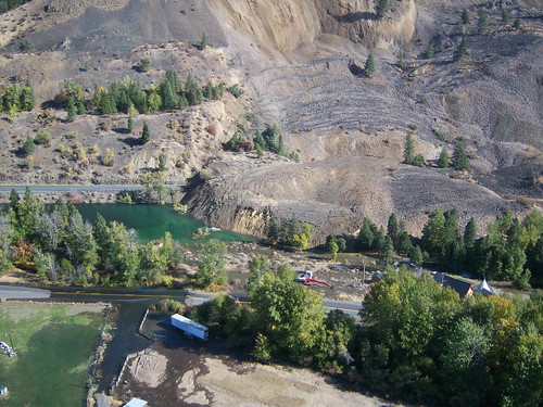
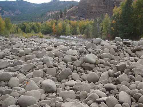
Some images from Google Earth and Google Maps of an area of significant lava and river interaction in Argentina. Field Trip! The center of the image is approximately 36.40 S, 69.42 W.

This site was discussed in the following talk:

GEOMORPHIC HISTORY OF RIVERS DRAINING THE EASTERN ANDEAN CORDILLERA (34–37°S) CONSTRAINED BY TEPHROCHRONOLOGY, U-SERIES DATING OF PEDOGENIC CARBONATE AND COSMOGENIC 3HE DATING OF BASALT FLOWS

HYNEK, Scott A., Geology and Geophysics, University of Utah, 115 S 1460 E, Salt Lake City, UT 84112-0119, scott.hynek@utah.edu, MARCHETTI, David W., Geology Program, Western State College of Colorado, 600 N. Adams St, Gunnison, CO 81231, FERNANDEZ, Diego P., Geology and Geophysics, University of Utah, 115 S. 1460 E. Rm 383, Salt Lake City, UT 84112, and CERLING, Thure E., Department of Geology and Geophysics, University of Utah, Salt Lake City, UT 84112Alluvial deposits and associated geomorphic features are dated by their relation with volcanic rocks. The age range and geologic setting requires a broad approach to constraining the history of rivers draining the Cordillera. Maximum age estimates are provided by identification of the ~ 450 ka Diamante Tuff in fill terraces. Along the Río Diamante this ash bed is observed >100 m above modern river level. In the Río Papagayos and Río Atuel drainages, the Diamante Tuff is associated with alluvial surfaces much closer to modern river level. Coarse Diamante pumice in the Río Atuel implies significant changes to the headwater drainage system since 450 ka. The maximum age constraint implied by occurrence of the Diamante Tuff in fill terraces has been successfully combined with minimum age estimates from cosmogenic 10Be approaching 350 ka (Baker et al., 2009). The relatively old age of alluvial surfaces in the region is additionally supported by U-series age estimates derived from pedogenic carbonate in volcanic soils. A minimum age in excess of 100 ka is conservative. The dated surface is underlain by a pumice/lapilli tephra deposit and basalt flows both of which have the potential to provide maximum age estimates for the surface. Conversely, the U-series data implies that the basaltic volcanism is older than 100 ka. Our age estimates of flows in several drainages are much younger. Cosmogenic 3He concentrations in hornblende from basaltic-andesites erupted along the Río Salado indicate exposure, and therefore eruption, ages younger than ~ 6 ka. These flows temporarily dammed the Río Salado in one location and bedrock incision below the level of the flows has occurred since. 3He concentrations in olivine from basaltic rocks at northeastern Volcán Payún Matru indicate a shield-building phase at ~ 40 ka. Recent basaltic aa flows from multiple vents are morphologically quite young and 3He exposure ages are forthcoming for one of them. The Río Grande has incised the older flows, and provides an average incision rate over a full glacial cycle. Combination of geochronological data from the region indicates provides accurate, if not tightly constrained, ages for alluvial surfaces and identifies spatially variable geomorphic rates influenced, in part, by contemporaneous volcanism.


Posted via email from Fresh Geologic Froth

Lava v. River example from British Columbia

Kathy C. turned me on to this example yesterday. I had no idea. Lava flow is only about 250 yrs old. It is in the Stikine Volcanic Field. There is a related, somewhat brief, paper:

Roberts, M.C. and McCuaig, S.J., 2001, Geomorphic responses to the sudden blocking of a fluvial system: Aiyansh lava flow, northwest British Columbia. The Canadian Geographer, v. 45, n. 2, p. 319-323.

The vent is located at 55.11 N, 128.89 W.

Field trip!

Posted via email from Arbitrary Frothings

Thursday, October 22, 2009

Submerged tree in Clear Lake, Oregon

This underwater picture shows a lone submerged tree in Clear Lake, OR.
There are many more than this. One (maybe most) date to about 2700 yrs
bp when a lava dam blocked the McKenzie River. Freezing water,
exceptionally clear.

Posted via email from Fresh Geologic Froth

Wednesday, October 21, 2009

Friday, October 16, 2009

Owyhee lava and river profiles: location

Posted via email from Fresh Geologic Froth

Owyhee lava and river profile figure...draft

Finally devised a way to confidently and easily extract profile data from the LiDAR data set in GlobalMapper. Surface profiles are simple. Basal profiles shown here are estimates based on some point measurements. Will vastly improve the basal profiles when GSA is over. Needed this figure, however, so spent too much time devising the method. 

Only issue now is to develop a technique for efficiently normalizing all the profiles to a reference thalweg of some sort. Already have data in xyz, so a quasi 3-D diagram would be the most realistic. 

Need to talk about this with the group.

Posted via email from Fresh Geologic Froth

Wednesday, October 14, 2009

Nice renditions of the Owyhee River area map

Preparing for my GSA lava talk and came up with these new versions of
the map of the Owyhee River study area. The second one is just the lava.

Posted via email from Fresh Geologic Froth

The lava flow-landslide link laid bare

This one supports the tenet:

'Intracanyon lava flows, the gifts that keep on giving'.

A garishly colored map that underscores the tight linkage between
landslides and lava flows on the Owyhee. If it is not the margin of
the lava flow that is failing, then it is the canyon wall that the
lava flow forced the river against that is failing (or both).
Certainly a tight coupling in this reach, no?

Posted via email from Fresh Geologic Froth

Two pleasing renditions of the map

Preparing for my GSA lava talk and came up with these new versions of
the map. The second one is just the lava.

Posted via email from Fresh Geologic Froth

Bogus Rim Lava / Iron Point Dam...beginner's edition

Posted via email from Fresh Geologic Froth

Bogus Rim Lava / Iron Point Dam

An obvious, but overlooked addition to the Oywhee River lava-dammed lake story. This is the approximate extent of the early Pleistocene lake caused by a Bogus Rim lava dam crest of 1210 m at Iron Point.

Posted via email from Fresh Geologic Froth

Monday, October 12, 2009

West Crater and Saddle Butte lava faceoff at Ryegrass Creek

This upstream-looking 3-D block rendition of the Ryegrass Creek area on the Owyhee is intriguing. The color ramp works well here because the strata are flat-lying. Note the boulder-covered and very flat surface below the Qbsy and above Ryegrass Creek...I suspect it relates to the pre-Saddle Butte lava Owyhee or Ryegrass Ck channel in some way, but I have never actually stood on it. Also, look at the morphology of the eastern edge of the Qbsy where the lacustrine seds sit...distinct linear trace there was map as fault by Ferns et al., but isn't it just the contact between the paleovalley wall and the lava? What about that abrupt wall in the Qbsy flow just beyond there? Looks like it is heading down a narrow valley.

Posted via email from Fresh Geologic Froth

Thursday, October 8, 2009

Some intriguing LiDAR-based block models from the Owyhee

These images of the Owyhee River LiDAR data were made using Surfer 9. They are amazing.

Posted via email from Fresh Geologic Froth

Thursday, October 1, 2009

State of the Owyhee Map: 10/01/09

These images each depict a part of the Owyhee River map area at 1:50000. The various fluvial units are generalized somewhat because it is too hard to resolve them at this scale. I began working on the map in earnest back in August 2007 and it has come an extremely long way since then. A preliminary version was already complete by the time we got the LiDAR data in March of 2008. Since then, I have probably put more time in on revising the map in light of (pun, get it?) of the LiDAR data. I do not even want to tally the 100s of hours I have spent in the field and in the office working on this thing.

What is left:

1. I need to do a full pass through the entire map and fix the topology and the line attribution and final fine-tuning. I have already started this in the Hole in the Ground area.
2. Unit descriptions need to be written up using Cooper's thesis as a base. This part will require input from all principal members of the research team
3. Accompanying text to the map. This will be a detailed accounting of the geologic history implied / required by the geologic map.
4. Send the whole package out for review. Likely, we will do this through DOGAMI who have agreed to publish the map if we can cover most / all of the costs.

Now, back to the lower Walker River map due in 15 days.

Posted via email from Fresh Geologic Froth

Wednesday, September 30, 2009

Geologic Map of the central Hole in the Ground area, Owyhee River, OR

Screenshot that shows the current status of my mapping in a key area. Landslides are green and broken into three relative ages (brighter=younger). Red lines have not been attributed yet. Map is coming along nicely.

Posted via email from Fresh Geologic Froth

Tuesday, September 29, 2009

Owyhee Mapping Project: All traverses by your pal, Kyle.

Ok, so maybe I spent enough time out there in 2007, 2008, and 2009. Yikes. As expected, the parts of the map that are the hardest to compile in the office are those areas I never hit on the ground.

Posted via email from Fresh Geologic Froth

My 2009 field traverses in the Owyhee River study area

Yes. I am a little late on getting my NSF annual report done...why these are due 3 months before the end of the year in question is beyond me. Most annual reports are due within 3 months of the end of the contract year. I suspect that someone made a mistake in the original paperwork and simply won't own up to it. 

Anyway, getting the report together has given me a chance to organize my field data more completely. Here are the traverses from this year. This includes the group trip in late May, my field camp stint in early June, and a solo trip in August.

The utterly obvious concept of making a traverse map is made very simple with a Garmin 60csx, the DNR Garmin (free) software, and ArcGIS. But, hey, you already knew that because you record all of your field traverses that way, right?

Posted via email from Fresh Geologic Froth

LiDAR-derived contours are useful, too.

Sure, I have gone on and on about the amazing visualizations you can get with some tweaking of LiDAR data; however, it turns out that a pretty basic representation is also quite useful...contours. Yes, contours. Sometimes smaller scale features remain somewhat ambiguous in hillshades or slopeshades, but high-res, short interval contours from the LiDAR data can eliminate most of the ambiguity. In this case, it is a tiny area that I have struggled with on the Owyhee River. Here, a large landslide entered from the north, shoved the river channel to the south, and the river eventually worked its way back to the north to some extent. The array of surficial deposits in the void that comprises the right hand side of the image south of the river record this sequence of events as well as subsequent sedimentation by tributary fans. The contours really highlight the fans, and in conjunction with discernible drainage patterns evident in the LiDAR, it is clear what is fan and what is river, right?

2-m Contours were generated in GlobalMapper and exported as shapefile to view in Arc.

Note, Ian Madin (at DOGAMI) gave me the tip on contours especially as they relate to resolving fan features. He was right...it works!

Posted via email from Fresh Geologic Froth

Extent of lake caused by the Greeley Bar lava dam

I created this lake by generating a contour from the LiDAR dataset at an elevation of 1046 m. GlobalMapper does this in about 1.5 minutes. Then, exported the vector as a shapefile, cut out the parts of the line that occur downstream from the dam, stitch the remaining loose ends, build a poly from the line and there it is.

This lake has an interesting topographic correspondence with the old landslides on the south side of the Hole in the Ground as well as the ancient fan remnants that come in from the north side. Don't forget that much of the topography you can see through the lake didn't exist at the time of the lava dam. The valley floor was probably formed on the Bogus Rim lava which forms the flat-topped features that flank the left and right banks of the river near the eastern end of the lake. The top of the Bogus Rim lava is only about 25 m below the surface of this lake. Thus, the link between this lake and the landslides is dubious as there was nowhere for the landslides to slide.

Posted via email from Fresh Geologic Froth

Plausible extents of landslide-dammed lakes in The Hole in the Ground

I have developed polygons showing likely extents of lakes related to both lobes of the Doublespring Landslide Complex on the Owyhee River. Using a combination of LiDAR data, ArcGIS, and GlobalMapper in conjunction with the highest plausible geomorphic evidence of fluvial overtopping the following lakes result:

East Spring Landslide: 878 m lake elevation.
West Spring Landslide: 868 m lake elevation.
(it is possible that both are a few meters low...need some field data)

The correspondence / lack of correspondence of these lakes with various upstream landforms and deposits is surprising.

Posted via email from Fresh Geologic Froth

Wednesday, August 19, 2009

Two New Gigapans, More on the Way

Our Owyhee River field area is very amenable to the gigapan. On my last trip I took the time to acquire several new GP images. Some are huge and still churning. But for now, check these out:

http://gigapan.org/viewGigapan.php?id=30647

http://gigapan.org/viewGigapan.php?id=30814

See the full gallery on posterous

Posted via email from Fresh Geologic Froth