

Wednesday, October 28, 2009
SR 410 Nile Valley Landslide (west of Naches)
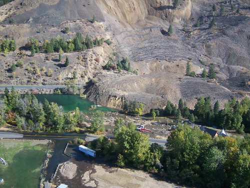
SR 410 Nile Valley Landslide (west of Naches), originally uploaded by Washington State Dept of Transportation.
An excellent view of the landslide...nicely done.
SR 410 Nile Valley Landslide (west of Naches)
SR 410 Nile Valley Landslide (west of Naches), originally uploaded by Washington State Dept of Transportation.
Check out the great photoset of the recent landslide near Naches, Washington.
http://www.flickr.com/photos/wsdot/sets/72157622438776353/
Saturday, October 24, 2009
Impressive lava-river interaction in Argentina
Some images from Google Earth and Google Maps of an area of significant lava and river interaction in Argentina. Field Trip! The center of the image is approximately 36.40 S, 69.42 W.This site was discussed in the following talk:
GEOMORPHIC HISTORY OF RIVERS DRAINING THE EASTERN ANDEAN CORDILLERA (34–37°S) CONSTRAINED BY TEPHROCHRONOLOGY, U-SERIES DATING OF PEDOGENIC CARBONATE AND COSMOGENIC 3HE DATING OF BASALT FLOWS
HYNEK, Scott A., Geology and Geophysics, University of Utah, 115 S 1460 E, Salt Lake City, UT 84112-0119, scott.hynek@utah.edu, MARCHETTI, David W., Geology Program, Western State College of Colorado, 600 N. Adams St, Gunnison, CO 81231, FERNANDEZ, Diego P., Geology and Geophysics, University of Utah, 115 S. 1460 E. Rm 383, Salt Lake City, UT 84112, and CERLING, Thure E., Department of Geology and Geophysics, University of Utah, Salt Lake City, UT 84112Alluvial deposits and associated geomorphic features are dated by their relation with volcanic rocks. The age range and geologic setting requires a broad approach to constraining the history of rivers draining the Cordillera. Maximum age estimates are provided by identification of the ~ 450 ka Diamante Tuff in fill terraces. Along the Río Diamante this ash bed is observed >100 m above modern river level. In the Río Papagayos and Río Atuel drainages, the Diamante Tuff is associated with alluvial surfaces much closer to modern river level. Coarse Diamante pumice in the Río Atuel implies significant changes to the headwater drainage system since 450 ka. The maximum age constraint implied by occurrence of the Diamante Tuff in fill terraces has been successfully combined with minimum age estimates from cosmogenic 10Be approaching 350 ka (Baker et al., 2009). The relatively old age of alluvial surfaces in the region is additionally supported by U-series age estimates derived from pedogenic carbonate in volcanic soils. A minimum age in excess of 100 ka is conservative. The dated surface is underlain by a pumice/lapilli tephra deposit and basalt flows both of which have the potential to provide maximum age estimates for the surface. Conversely, the U-series data implies that the basaltic volcanism is older than 100 ka. Our age estimates of flows in several drainages are much younger. Cosmogenic 3He concentrations in hornblende from basaltic-andesites erupted along the Río Salado indicate exposure, and therefore eruption, ages younger than ~ 6 ka. These flows temporarily dammed the Río Salado in one location and bedrock incision below the level of the flows has occurred since. 3He concentrations in olivine from basaltic rocks at northeastern Volcán Payún Matru indicate a shield-building phase at ~ 40 ka. Recent basaltic aa flows from multiple vents are morphologically quite young and 3He exposure ages are forthcoming for one of them. The Río Grande has incised the older flows, and provides an average incision rate over a full glacial cycle. Combination of geochronological data from the region indicates provides accurate, if not tightly constrained, ages for alluvial surfaces and identifies spatially variable geomorphic rates influenced, in part, by contemporaneous volcanism.

Lava v. River example from British Columbia

Kathy C. turned me on to this example yesterday. I had no idea. Lava flow is only about 250 yrs old. It is in the Stikine Volcanic Field. There is a related, somewhat brief, paper:
Roberts, M.C. and McCuaig, S.J., 2001, Geomorphic responses to the sudden blocking of a fluvial system: Aiyansh lava flow, northwest British Columbia. The Canadian Geographer, v. 45, n. 2, p. 319-323.
The vent is located at 55.11 N, 128.89 W.
Field trip!
Thursday, October 22, 2009
Submerged tree in Clear Lake, Oregon

This underwater picture shows a lone submerged tree in Clear Lake, OR.
There are many more than this. One (maybe most) date to about 2700 yrs
bp when a lava dam blocked the McKenzie River. Freezing water,
exceptionally clear.
Wednesday, October 21, 2009
Friday, October 16, 2009

Owyhee lava and river profile figure...draft

Finally devised a way to confidently and easily extract profile data from the LiDAR data set in GlobalMapper. Surface profiles are simple. Basal profiles shown here are estimates based on some point measurements. Will vastly improve the basal profiles when GSA is over. Needed this figure, however, so spent too much time devising the method.
Only issue now is to develop a technique for efficiently normalizing all the profiles to a reference thalweg of some sort. Already have data in xyz, so a quasi 3-D diagram would be the most realistic.
Need to talk about this with the group.
Wednesday, October 14, 2009
Nice renditions of the Owyhee River area map
Preparing for my GSA lava talk and came up with these new versions of
the map of the Owyhee River study area. The second one is just the lava.


The lava flow-landslide link laid bare

This one supports the tenet:
'Intracanyon lava flows, the gifts that keep on giving'.
A garishly colored map that underscores the tight linkage betweenlandslides and lava flows on the Owyhee. If it is not the margin of
the lava flow that is failing, then it is the canyon wall that the
lava flow forced the river against that is failing (or both).
Certainly a tight coupling in this reach, no?
Two pleasing renditions of the map
Preparing for my GSA lava talk and came up with these new versions of
the map. The second one is just the lava.
the map. The second one is just the lava.

Bogus Rim Lava / Iron Point Dam

An obvious, but overlooked addition to the Oywhee River lava-dammed lake story. This is the approximate extent of the early Pleistocene lake caused by a Bogus Rim lava dam crest of 1210 m at Iron Point.
Monday, October 12, 2009
West Crater and Saddle Butte lava faceoff at Ryegrass Creek
This upstream-looking 3-D block rendition of the Ryegrass Creek area on the Owyhee is intriguing. The color ramp works well here because the strata are flat-lying. Note the boulder-covered and very flat surface below the Qbsy and above Ryegrass Creek...I suspect it relates to the pre-Saddle Butte lava Owyhee or Ryegrass Ck channel in some way, but I have never actually stood on it. Also, look at the morphology of the eastern edge of the Qbsy where the lacustrine seds sit...distinct linear trace there was map as fault by Ferns et al., but isn't it just the contact between the paleovalley wall and the lava? What about that abrupt wall in the Qbsy flow just beyond there? Looks like it is heading down a narrow valley.


Thursday, October 8, 2009
Some intriguing LiDAR-based block models from the Owyhee
These images of the Owyhee River LiDAR data were made using Surfer 9. They are amazing.


Thursday, October 1, 2009
State of the Owyhee Map: 10/01/09
These images each depict a part of the Owyhee River map area at 1:50000. The various fluvial units are generalized somewhat because it is too hard to resolve them at this scale. I began working on the map in earnest back in August 2007 and it has come an extremely long way since then. A preliminary version was already complete by the time we got the LiDAR data in March of 2008. Since then, I have probably put more time in on revising the map in light of (pun, get it?) of the LiDAR data. I do not even want to tally the 100s of hours I have spent in the field and in the office working on this thing. What is left: 1. I need to do a full pass through the entire map and fix the topology and the line attribution and final fine-tuning. I have already started this in the Hole in the Ground area.
2. Unit descriptions need to be written up using Cooper's thesis as a base. This part will require input from all principal members of the research team
3. Accompanying text to the map. This will be a detailed accounting of the geologic history implied / required by the geologic map.
4. Send the whole package out for review. Likely, we will do this through DOGAMI who have agreed to publish the map if we can cover most / all of the costs. Now, back to the lower Walker River map due in 15 days.


Subscribe to:
Posts (Atom)