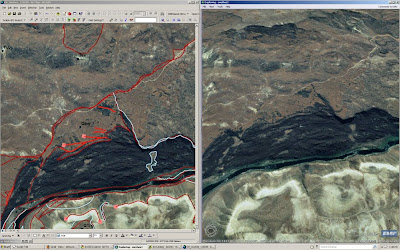
Using the vr is instructive, but it is most useful in topographically complex areas. Many of the lines I added were redundant with respect to prior flat mapping and field mapping. By placing the vr lines on high-res imagery using ArcExplorer (get it now) also proved just how useful it would be to be able to directly edit arc-ish linework. The screen shot below is what my computer looked like most of the day. The area is the large foundering slab of Qbw above Dogleg. Check the killer perspective on the right vs. the flat map perspective on the left. Note also that the overprinted lines on the left are the imported vr lines and the prior flat mapping lines. My goal is to now find out why I can't place vectors on precisely georeferenced images draped on topography.
 Check out ArcExplorer. It is free. Not as good as Google Earth, but possibly more functional? At least it has the high-res imagery for our area. Lastly, it cannot adequately render the gorge because of the extreme relief and some bad orthorectification inthe NAIP data. Turns out that careful orthorecitification of high-res photo scans in the vr has some (but less) trouble here. If we can drape images on the LiDAR and map on that....

No comments:
Post a Comment
Note: Only a member of this blog may post a comment.