
Monday, December 22, 2008
Friday, December 12, 2008
I'm done with the map, I'm done with the map, etc.

Finished just in time to attend a meeting about heavy budget cuts at UNR. Check the earlier entries to see how far this came. On this version, the lava dams are indicated and I have exercised my urges to name stuff.
I will only change something if it is factually and not only aesthetically erroneous.
Wednesday, December 10, 2008
I'm sick of the map, I'm sick of the map, I'm sick of the map, etc.
 Here is one version...had some plotter problems (shocking, no?) and dumbed the base down a little. This one is about 24 by 28.
Tuesday, December 9, 2008
I'm the map, I'm the map, I'm the map, etc.
 This is what I came up with for a draft layout for the map. I will add the base material images when back at my office computer. Any votes for shaded relief vs topo or some other possibility (e.g. a combination of those, the NAIP imagery, satellite imagery)? I am traveling after noon tomorrow and will be unavailable on Thursday and Friday. Weekend is possible, but I have a talk to prepare for AGU and haven't started that yet.
The draft above shows some labels on the lava flows. I could add more or delete the ones on there. Anyone have a preference? Let me know soon.
Owyhee Map for AGU...almost there


I have reached a point of no return on the map and have gotten close to a final draft for inclusion on AGU poster(s). In this version, a lot of the detail is left out:
no bedrock older than Bogus Rim flow
undivided landslides,
undivided mainstem fluvial deposits (active channel is divided),
undivided lacsutrine deposits.
Reasons: map is too complicated for showing everything and too many loose ends in some units (mainly generalized bedrock) to build polys.
The colors are chosen to highlight the various features and are obviously not conventional geologic map colors. Mainly, those conventions are a real annoyance when you map detailed surficial units anyway. The snippets in this post should give you a good idea of where things stand. I am leaving town tomorrow afternoon and cannot have this map hanging over my head...and I bet that spud is tired of waiting.
It will be pretty easy to create a basemap using these data as the 1:250,000 version indicates. I need some feedback on where to go from here.
Cool Tangent...Rocky Butte and Jordan Creek

I have been mapping the Q basalt flows that didn't make it to the Owyhee and have learned that the lava v. water situation on Jordan Creek is exceptionally cool and interesting. We should really check this out this spring if time permits. The photo here shows a very well developed overflow channel. It appears to have filled in and then incised some depressions on the flow surface. Lots of interesting features associated with this flow.
Map-tacular Effort
Great job on the mapping Kyle! I am looking forward to seeing it on our poster.
-Spud
-Spud
Monday, December 8, 2008

GeoMap-a-thon, Day 6. The curse of Topology
Put in 7 hours on map today to find an inexplicable topology error that precluded building polygons. I was so excited for this to happen. After lengthy consultation with local GIS supergeek, turns out that exporting feature dataset as shapefile and then reimporting it as feature dataset worked. Took 1.5 hours to figure that out. If you get this error in your life, don't panic like I did, it is not worth it (just follow the steps above):

Despite this roadblock, I made alot of progress. Will post map tomorrow AM...can't work on it much at all beyond tomorrow.

Despite this roadblock, I made alot of progress. Will post map tomorrow AM...can't work on it much at all beyond tomorrow.
Friday, December 5, 2008
Holy Crap, day 5 was a bad one

Lots of tedium, lots of cursing, lots of computer problems. Nonetheless, I made a lot of progress. Here is a snippet of the Bogus Rim / Lambert Area. Don't be alarmed...there are still some tiny holes that lead to bleeding polys. This does show my interp of the landslides vs. in situ rox in the Bogus Rim area. Until Monday....
Thursday, December 4, 2008
Yeehow GeoMap-a-thon, Day 4
I don't have a particularly meaningful map to post today. Have been mired in correcting imported linework from the vr...topology issues. However, did spend a lot of time mapping in the landslides coming off of Bogus Rim and had a good online chat with Spud about some contentious mapping calls of mine. Worthy of a group discussion in the field for sure.
Using the vr is instructive, but it is most useful in topographically complex areas. Many of the lines I added were redundant with respect to prior flat mapping and field mapping. By placing the vr lines on high-res imagery using ArcExplorer (get it now) also proved just how useful it would be to be able to directly edit arc-ish linework. The screen shot below is what my computer looked like most of the day. The area is the large foundering slab of Qbw above Dogleg. Check the killer perspective on the right vs. the flat map perspective on the left. Note also that the overprinted lines on the left are the imported vr lines and the prior flat mapping lines. My goal is to now find out why I can't place vectors on precisely georeferenced images draped on topography.
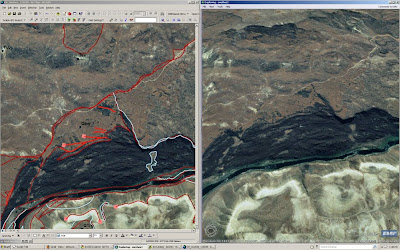 Check out ArcExplorer. It is free. Not as good as Google Earth, but possibly more functional? At least it has the high-res imagery for our area. Lastly, it cannot adequately render the gorge because of the extreme relief and some bad orthorectification inthe NAIP data. Turns out that careful orthorecitification of high-res photo scans in the vr has some (but less) trouble here. If we can drape images on the LiDAR and map on that....
Wednesday, December 3, 2008
Yeehow GeoMap-a-thon Day 3-D
 No map to post today, instead here is a shot of me totally geeked-out (electric glasses, mp3 player, Blackberry) working away on the map. The 3-D mapping is great, but it takes some serious time. Since it allows you to check the elevation of any point in the image, it allows for some checks of in situ vs. landslide strat...this has led to some significant reinterpretations of the suite of landslides off of Bogus Rim...lots to talk about. Lots more in situ rock there than appears at first, second, and third glance.
Tuesday, December 2, 2008
Yeehow GeoMap-a-Thon day 2
Good progress today despite interminable interruptions. Heather (NBMG Yeehow in training...YIT) set up Rome Valley on the VR today...the 3-D computer mapping device. I will get to mapping that in more detail tomorrow AM. 3-D will help immensely in that reach. Have relied on much of Cooper's mapping to get the lava flow extents. Some refinement added. Some questions about where some begin and where some end still remain. Anyway, here it is:


Monday, December 1, 2008
A big week for the Yeehow GeoMap

Howdy. Here is a 1:200k version of the map as it stands at the end of the day today. I will commit to updating this image via blog entry each day through Friday as a form of personal motivation. Many of the color bleeds will go away with some topology corrections and some additional lines. Yes. I did start mapping the Q lava flows to their sources. At some point, I need a little help from Cooper with this. Note the major league lava-water interface in the Danner area (east of Arock)...yowza. Looks like a good side trip for Yeehows. Totally cool and unexpected (by me, at least). Sometimes it is good to look beyond the map area, no?
Subscribe to:
Posts (Atom)