

Monday, June 15, 2009
Page size map in progress...really.
Sure, I have made one of these before, but now we are closing in on the penultimate representation. My life can only afford two more trips into the field this summer and fall. Next comes the simplified explanation.

Friday, June 12, 2009
Desecration or Inspiration? You decide.

A new digital experience on the rim of the Owyhee Canyon. Turns out, it was a brilliant idea. You would love to see the LiDAR this large. It was a great way to review the day's transect and show pictures of stuff the students didn't get to see on the foreshortened tour of the muddy field area. Good plan for a formal field trip. Trust me, it works.
Sorry Yeehows, Our Secret is Out
 The hydrograph above effectively encapsulates the ambient conditions of field camp. The overall wetness was pretty freaking shocking.
 The field camp experiment is over. It was a muddy success. The region was (and still may be) under the influence of a persistent cutoff low pressure system that delivered record amounts of rainfall. It is true that the roads on the rim become somewhat challenging when they get wet, but we did manage to get seven vehicles all the way in and out to the Artillery Rim camp site (eventually). The first night at Rome launch, it rained nearly 1.5 inches. A record for Rome. It was truly disheartening. While lamenting my plight at the Rome Cafe very early on Saturday, the woman in charge at the time offered up access to the Grange building in Arock for us to use while we waited out the rain. Once in Arock, we were given access to the Arock School by an extremely gracious host. The school was a perfect fit for us...hot water, bathrooms, class rooms with high-speed internet, a playground, etc.
While at the school waiting out the rain, I gave a marathon lecture (with playground breaks) about the study area, the Quaternary, surficial geologic mapping, and of course provided various demonstrations about geotagging photos, how the gigapan robot works, how I make a map in ArcGIS, and how the magic pen works.
Thankfully, Duane and Caitlin were also there. Duane gave a lecture about the history of paleomagnetism and described how it works in the case of correlating basalt units in the field area.

Caitlin gave a lecture about her project. That night it rained like hell and we enjoyed watching a major thunderstorm plow through Arock. All the more enjoyable because we had a dry place to sleep.
The next day, we had a foreshortened tour of the field area (mud concerns) and made it to the Coffee Pot lava field and the vent by way of the Rockhouse Coffee Shop...all great places to take students.

The road to Birch Creek was in good shape so we peered over the rim. The students were moderately amazed because all they had seen of the river so far was the boring reach at Rome. We then headed out through JV and actually made it to Artillery Rim with only minor mud delays.
Once at the camp site, we approached the rim on foot as a group, and it was the perfect field camp moment. Everyone was awestruck by the view from there.

What then ensued were two perfect field days in the Artillery Rim landslide complex...full of ticks and snakes (lots of snakes), but the weather was perfect. The students had never faced such a complex array of landforms and deposits. Rest assured they have newfound respect for rivers, canyons, and Quaternary geology (and rattlesnakes).
 The field camp mascot...saw 9 or 10 rattlesnakes in two days.
 Here's an idea. Bring the girls from the Mackay School of Mines Mining Team into the field to dig for you. Next year, the augering competition. In less than 15 minutes they created the best exposure of the Qfl that any of us has ever seen.
The last day ended with an all night soaking rain, and we (the TAs, the cook, and I) were concerned that we may be stuck for a day. It was extremely wet that morning. But, alas, Duane (who proved various times on the trip that his last name is no fluke) and his field assistant Nicole showed up at our camp around 8 AM proving that the roads were viable. As we then rapidly started to take the camp down, it started to rain very hard and things were horribly wet. As we pulled out of the camp, there was a lot of water running down the rocky road past the gate. The rim roads were muddy as hell in the immediate area and one van got mired. It was a relatively easy extraction and we were again on our way through the mud. As we approached the (once-named) veneers of dreaded rim gravel, we changed the name to the sanctified rim gravel. The roads were fine and we proceeded out of the field with no incident.
Looks like my UNR field camp session will hit the Owyhee every year. It remains an amazing place worthy of sharing.

A beautiful evening looking north over the Artillery Rim landslide complex. Worth the trip.
Tuesday, June 2, 2009
Trip re-cap: The Boulders
This year's group trip to the Owyhee was a great success. I, with much help from everyone, filled in some gaps in the map and the stratigraphy; we all found some new stuff; explored some new areas; acquired valuable field data; and met some very cool people. I am madly compiling the gigpans I took and just remembered that I needed to reduce the GPS data for the boulder measurements. Just got that done. Here are some screen shots:
Bunny's Bar:

Artillery bar:

Look at each and note the very high correspondence between the two types of data--LiDAR and High-Precision GPS. It is a whole new world. Don't fall off.
Bunny's Bar:

Artillery bar:

Look at each and note the very high correspondence between the two types of data--LiDAR and High-Precision GPS. It is a whole new world. Don't fall off.
Friday, April 10, 2009
Imbricated thoughts on gravel, pt. 2
 Now the high gravels. Maybe I haven't shared this with the entire group, but there are very, very sparse gravels in very few locations near the western edge of the Bogus Rim lava (Qbbr). Cooper and I spotted some in October 07 and I saw them again in Oct 08 and got a precise GPS reading on them of 1194 m. This is the level of the highest gravels upstream (skirting Little Owyhee Butte), but I haven't gotten a gps reading on them to really pin it down yet (May trip). Thus, these most likely represent the effect of damming by the Qbbr. The edge elevation of the Qbbr approaches 1204 m at the narrowest gap between it and the west edge of the Gorge at Iron Point. Note that the copious (6 m thick) volcanic-clast dominated overflow gravel appears downstream from the likley point of blockage at an elevation of 1160 to 1140. Suggests clearwater pour-over of the blockage to me.
Other high gravel elevations of note include the gravels on the Ice-Axe (1148 m), the low Rim Gravels on the tip of Bogus Point ( 1114 m), and the lone gravel deposit on the West Crater Kipuka (1050 m). More on them later.
Imbricated thoughts on gravel, pt. 1
 Have lately been thinking about gravel deposits along the Owyhee. Using the LiDAR data, it is possible to rapidly extract precise elevation data from any point within the swath. This allows for a quick appraisal of the potential significance of the positions of various gravel deposits. In this image, I have highlighted some interesting spots. Of particular interest here are the gravels at the 993-995 m level ('perimeter gravels'). These are roughly concordant with the height of the west edge of the the West Crater flow and probably define the position of the first established channel of the river on its way through the lava. These surfaces stand well above the highest gravels at Dogleg, but that gradient is controlled by the gradient of the lava flow. What of the large difference between the elevation of the perimeter gravels and the next level down at Dogleg...a 33 m difference over only 3 km? Steep.
Also of note in the figure are the gravel deposits in the 1017-1025 m range (need to step on these sites before too long). These deposits must pre-date the West Crater flow and would have flanked the paleochannel that it followed. I was pleased to notice that the 1017 m gravel coincides with a prominent scarp-ish feature that is fairly obvious on the east side of the valley. Suggestive of gooey paleovalley margin for sure.
More posts on other gravel issues to come. Feel free to participate.
Wednesday, April 8, 2009
Bogus Rim lava now ~solidly in Quaternary!
According to the new geologic time scale being promulgated by GSA as well as the IUGS:


Monday, March 30, 2009

Sunday, March 29, 2009
Maybe it has all been virtually fake?


Well, the LiDAR has shown us that a digitally rendered landscape offers, in some ways, more insights into the geology than a picture, a hike, or a stereo model. Of course, the field observations are the most fun and provide the true context that allow us to gain those epiphanic insights. But...have we ever done any real field work? After going through some old photos I started to wonder if the whole thing has been a synthesized digital construct fed into my brain from some inscrutable computer network. I believe these are KC's photos.
Wednesday, March 25, 2009
Bullseye Bar in Surfer
 Surfer is an old favorite of mine...it is good for quickly displaying the data and creating intuitive views. I think that this perspective clarifies the geometry and orientation of the landslide.
Dogleg Bar in Quick Terrain Modeler

Just fired up QTM today to see what it is all about. I can tell it is powerful, but am not yet qualified to use it. Working on it.
Thursday, March 12, 2009
Profile Prototype

Here is a first stab at a simple, annotated profile from the LiDAR data. It is a very slightly smoothed curve. I used a 50 point weighted average to get the smoothest profile that clearly mimicked the more data-rich version.
Have not yet gotten to extracting the lava flow profiles, but have added their longitudinal extents. Also added the main landslide complexes and some key sites to enable yeehow orientation. Overall the profile is pretty good. The only aberrant points show up where I tried to 'drive around' some of the no-data points and ended up treading on a terrace, so to speak. Next example will be the longitudinal changes in local gradient.
Friday, March 6, 2009
Olivine Separates: 051107-2(3)

Here are some images that show that status of the olivine mineral separation efforts. This sample contains the most olivine so far. It is one of two samples from the upstream end of T4 in The Hole in the Ground. Can someone tell me if two samples were collected from the same rock?
Anyway the point of this post is to show Cassie the status of our efforts to separate and clean the olivine crystals. On several crystals you can see some adhering matrix crud. We know we need to get that off. As for the black specks...?
Thursday, March 5, 2009


Tuesday, February 10, 2009
Cosmic Mineral Separation Initiative


The cosmic mineral separation directive has officially been implemented at NBMG. I now actually understand what we are doing and learned how a microscope works. Turns out looking for olivine makes my hair grow.
I have received much help from colleagues Nick (of previous 3D mapping fame) and Bret (shown in photo). Bret is doing nearly all of the work. Nick is providing more guidance than I am because he separates minerals for Ar-Ar all of the time. I (we) am (are) paying Bret for all of this work. Have also gotten some billets for thin sections out of the deal.
Sunday, January 11, 2009
Can you guess where this is?
Hint: SWA Flt 2268


 You can clearly see the RB, CB, WC, BR lavas in this one.
 Here you can see the WC vent and the main lava tube. Rad.
-Spud


 You can clearly see the RB, CB, WC, BR lavas in this one.
 Here you can see the WC vent and the main lava tube. Rad.
-Spud
Tuesday, January 6, 2009
Monday, December 22, 2008
Friday, December 12, 2008
I'm done with the map, I'm done with the map, etc.

Finished just in time to attend a meeting about heavy budget cuts at UNR. Check the earlier entries to see how far this came. On this version, the lava dams are indicated and I have exercised my urges to name stuff.
I will only change something if it is factually and not only aesthetically erroneous.
Wednesday, December 10, 2008
I'm sick of the map, I'm sick of the map, I'm sick of the map, etc.
 Here is one version...had some plotter problems (shocking, no?) and dumbed the base down a little. This one is about 24 by 28.
Tuesday, December 9, 2008
I'm the map, I'm the map, I'm the map, etc.
 This is what I came up with for a draft layout for the map. I will add the base material images when back at my office computer. Any votes for shaded relief vs topo or some other possibility (e.g. a combination of those, the NAIP imagery, satellite imagery)? I am traveling after noon tomorrow and will be unavailable on Thursday and Friday. Weekend is possible, but I have a talk to prepare for AGU and haven't started that yet.
The draft above shows some labels on the lava flows. I could add more or delete the ones on there. Anyone have a preference? Let me know soon.
Owyhee Map for AGU...almost there


I have reached a point of no return on the map and have gotten close to a final draft for inclusion on AGU poster(s). In this version, a lot of the detail is left out:
no bedrock older than Bogus Rim flow
undivided landslides,
undivided mainstem fluvial deposits (active channel is divided),
undivided lacsutrine deposits.
Reasons: map is too complicated for showing everything and too many loose ends in some units (mainly generalized bedrock) to build polys.
The colors are chosen to highlight the various features and are obviously not conventional geologic map colors. Mainly, those conventions are a real annoyance when you map detailed surficial units anyway. The snippets in this post should give you a good idea of where things stand. I am leaving town tomorrow afternoon and cannot have this map hanging over my head...and I bet that spud is tired of waiting.
It will be pretty easy to create a basemap using these data as the 1:250,000 version indicates. I need some feedback on where to go from here.
Cool Tangent...Rocky Butte and Jordan Creek

I have been mapping the Q basalt flows that didn't make it to the Owyhee and have learned that the lava v. water situation on Jordan Creek is exceptionally cool and interesting. We should really check this out this spring if time permits. The photo here shows a very well developed overflow channel. It appears to have filled in and then incised some depressions on the flow surface. Lots of interesting features associated with this flow.
Map-tacular Effort
Great job on the mapping Kyle! I am looking forward to seeing it on our poster.
-Spud
-Spud
Monday, December 8, 2008

GeoMap-a-thon, Day 6. The curse of Topology
Put in 7 hours on map today to find an inexplicable topology error that precluded building polygons. I was so excited for this to happen. After lengthy consultation with local GIS supergeek, turns out that exporting feature dataset as shapefile and then reimporting it as feature dataset worked. Took 1.5 hours to figure that out. If you get this error in your life, don't panic like I did, it is not worth it (just follow the steps above):

Despite this roadblock, I made alot of progress. Will post map tomorrow AM...can't work on it much at all beyond tomorrow.

Despite this roadblock, I made alot of progress. Will post map tomorrow AM...can't work on it much at all beyond tomorrow.
Friday, December 5, 2008
Holy Crap, day 5 was a bad one

Lots of tedium, lots of cursing, lots of computer problems. Nonetheless, I made a lot of progress. Here is a snippet of the Bogus Rim / Lambert Area. Don't be alarmed...there are still some tiny holes that lead to bleeding polys. This does show my interp of the landslides vs. in situ rox in the Bogus Rim area. Until Monday....
Thursday, December 4, 2008
Yeehow GeoMap-a-thon, Day 4
I don't have a particularly meaningful map to post today. Have been mired in correcting imported linework from the vr...topology issues. However, did spend a lot of time mapping in the landslides coming off of Bogus Rim and had a good online chat with Spud about some contentious mapping calls of mine. Worthy of a group discussion in the field for sure.
Using the vr is instructive, but it is most useful in topographically complex areas. Many of the lines I added were redundant with respect to prior flat mapping and field mapping. By placing the vr lines on high-res imagery using ArcExplorer (get it now) also proved just how useful it would be to be able to directly edit arc-ish linework. The screen shot below is what my computer looked like most of the day. The area is the large foundering slab of Qbw above Dogleg. Check the killer perspective on the right vs. the flat map perspective on the left. Note also that the overprinted lines on the left are the imported vr lines and the prior flat mapping lines. My goal is to now find out why I can't place vectors on precisely georeferenced images draped on topography.
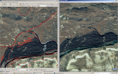 Check out ArcExplorer. It is free. Not as good as Google Earth, but possibly more functional? At least it has the high-res imagery for our area. Lastly, it cannot adequately render the gorge because of the extreme relief and some bad orthorectification inthe NAIP data. Turns out that careful orthorecitification of high-res photo scans in the vr has some (but less) trouble here. If we can drape images on the LiDAR and map on that....
Wednesday, December 3, 2008
Yeehow GeoMap-a-thon Day 3-D
 No map to post today, instead here is a shot of me totally geeked-out (electric glasses, mp3 player, Blackberry) working away on the map. The 3-D mapping is great, but it takes some serious time. Since it allows you to check the elevation of any point in the image, it allows for some checks of in situ vs. landslide strat...this has led to some significant reinterpretations of the suite of landslides off of Bogus Rim...lots to talk about. Lots more in situ rock there than appears at first, second, and third glance.
Tuesday, December 2, 2008
Yeehow GeoMap-a-Thon day 2
Good progress today despite interminable interruptions. Heather (NBMG Yeehow in training...YIT) set up Rome Valley on the VR today...the 3-D computer mapping device. I will get to mapping that in more detail tomorrow AM. 3-D will help immensely in that reach. Have relied on much of Cooper's mapping to get the lava flow extents. Some refinement added. Some questions about where some begin and where some end still remain. Anyway, here it is:


Monday, December 1, 2008
A big week for the Yeehow GeoMap

Howdy. Here is a 1:200k version of the map as it stands at the end of the day today. I will commit to updating this image via blog entry each day through Friday as a form of personal motivation. Many of the color bleeds will go away with some topology corrections and some additional lines. Yes. I did start mapping the Q lava flows to their sources. At some point, I need a little help from Cooper with this. Note the major league lava-water interface in the Danner area (east of Arock)...yowza. Looks like a good side trip for Yeehows. Totally cool and unexpected (by me, at least). Sometimes it is good to look beyond the map area, no?
Subscribe to:
Posts (Atom)