Wednesday, October 31, 2007

OSL sample 3

This was a 'choice' sample location in terms of sediments and stratigraphic position. This is not too high above the river on river right, well below the top of the West Crater flow. It remains to be seen as to whether this is lacustrine sediment associated with the West Crater Dam. If so, these sediments provide a constraint on the paleo-profile at the time (and place it lower than I would have suspected). Upper photo shows where we sampled and also the location of the tephra bed higher in the section (the white line with some obvious digging disturbance). The lower photo shows the exact sample spot at the base of the exposure. Sample 10050704. This is the stratigraphically lowest sample. This sample is in the top tier of priority for analysis because it seems like an ideal case.


OSL Samples 1 and 2

I am finally getting around to submitting the OSL samples to the lab at Utah State. I am posting photos of the sample sites for everyone's information. The photo below is from the location at the upstream end of the West Crater Flow below Bogus Point on river right. Here we sampled some likely fluvio-lacustrine seds that are capped by eolian sediments. Two samples here that straddle a boundary formed by a silty bed. Samples from here are 10050703a and b. This package is the highest exposure relative to the river. These two are the lowest tier priority owing to the clay beds.

Tuesday, October 30, 2007

Take Aim at the First Stab at a Correlation Diagram

NBMG recently hired a new chief cartographer with an extensive background in ArcGIS. As a consequence, our new approach to geodatabases is very comprehensive. I am climbing a relatively steep learning curve as I figure it out. One interesting aspect is that the new structure can pull a correlation diagram designed in excel (of all things!) right into a map layout. Any changes to labels and colors on the map are automatically updated in the correlation diagram.

Thus, instead of just mapping nonstop since we left Bend, I have been tackling the basic logistical issues associated with organizing the map data (see previous posts on unit labels and line types). So, today I tackled the correlation diagram. Please look this over and provide any comments you may have. Typically this type of chart evolves as the mapping progresses, but the first stab has to be decent. If you want to edit the spreadsheet directly, let me know and I will forward it. Note that I have added a chronological component to the landslide units. Not sure how easy it will be to divide, but decided the option was important to have.

Correlation Diagram of Late Cenozoic Geologic Units along the Owyhee River, Oregon

First draft, P.K. House, NBMG

Monday, October 29, 2007

Geodatabase to the nth degree

OK, this is a long one, but I wanted everyone to see the set of line-codes that I am integrating into the geodatabase. The codes are based on terminology in the new digital geologic map standards published by the FGDC. The seemingly overly detailed list is based on degrees of certainty relative to two aspects of lines on a geologic map: 1. What sort of line it is and how certain you are about that; and 2. How well the line's location is known.

Each funny looking code is a combination of the following characters that account for a variety of lines and a variety of degrees of certainty about what and where they are:

Line Types [kind]
  • C Contact
  • X Fault
  • R Rock body (marker bed or key bed)
  • Z Scarp (as feature, not contact)
  • M Morphologic
  • B Boundary
Prefixes [category]
  • g generic
  • l landslide
  • i internal
  • f fluvial
  • v volcanic
  • s sedimentary
  • z scarp
  • d depression
  • m morphologic feature
Suffixes [location]
  • c certain
  • q questionable
  • a accurate
  • x approximate
  • c concealed
  • i inferred
Code followed by Name
  • uB Boundary—undifferentiated
  • mB Boundary—mapsheet
  • pB Boundary—property
  • sB Boundary—scratch
  • wB Boundary—water
  • eB Boundary—exclusion
  • gCca Contact—Identity and existence certain, location accurate
  • gCqa Contact—Identity or existence questionable, location accurate
  • gCcx Contact—Identity and existence certain, location approximate
  • gCqx Contact—Identity or existence questionable, location approximate
  • gCci Contact—Identity and existence certain, location inferred
  • gCqi Contact—Identity or existence questionable, location inferred
  • iCca Internal contact—Identity and existence certain, location accurate
  • iCqa Internal contact—Identity or existence questionable, location accurate
  • iCcx Internal contact—Identity and existence certain, location approximate
  • iCqx Internal contact—Identity or existence questionable, location approximate
  • sCca Incised-scarp sedimentary contact—Identity and existence certain, location accurate.
  • sCqa Incised-scarp sedimentary contact—Identity or existence questionable, location accurate.
  • sCcx Incised-scarp sedimentary contact—Identity and existence certain, location approximate.
  • sCqx Incised-scarp sedimentary contact—Identity or existence questionable, location approx.
  • ldCca Sag-pond or closed depression on landslide (mapped to scale)
  • viCca Contact separating individual lava flows within same map unit—Identity and existence certain, location accurate
  • viCcx Contact separating individual lava flows within same map unit—Identity and existence certain, location approximate
  • viCqx Contact separating individual lava flows within same map unit—Identity or existence questionable, location approximate
  • gXca Fault (generic; vertical, subvertical, or high-angle; or unknown or unspecified orientation or sense of slip)—Identity and existence certain, location accurate
  • gXqa Fault (generic; vertical, subvertical, or high-angle; or unknown or unspecified orientation or sense of slip)—Identity or existence questionable, location accurate
  • gXqx Fault (generic; vertical, subvertical, or high-angle; or unknown or unspecified orientation or sense of slip)—Identity or existence questionable, location approximate
  • gXcc Fault (generic; vertical, subvertical, or high-angle; or unknown or unspecified orientation or sense of slip)—Identity and existence certain, location concealed
  • kRca Key bed—Identity and existence certain, location accurate
  • kRcx Key bed—Identity and existence certain, location approximate
  • fZca Fluvial terrace scarp—Identity and existence certain, location accurate. Hachures point down scarp
  • fZqa Fluvial terrace scarp—Identity or existence questionable, location accurate. Hachures point down scarp
  • fZcx Fluvial terrace scarp—Identity and existence certain, location approximate. Hachures point downscarp
  • lZca Head or main scarp of landslide—Active, sharp, distinct, and accurately located. Hachures point down scarp
  • lZcx Head or main scarp of landslide—Inactive, subdued, indistinct, and (or) approximately located. Hachures point down scarp
  • liZca Internal or minor scarp in landslide—Active, sharp,distinct, and accurately located. Hachures point down scarp
  • liZcx Internal or minor scarp in landslide—Inactive, subdued, indistinct, and (or) approximately located. Hachures point down scarp
  • vMca Flow lobe or lava-flow front—Identity and existence certain, location accurate. Hachures on side of overlying younger flow
  • vMqa Flow lobe or lava-flow front—Identity or existence questionable, location accurate. Hachures on side of overlying younger flow
  • vMcx Flow lobe or lava-flow front—Identity and existence certain, location approximate. Hachures on side of overlying younger flow
  • vMqa Flow lobe or lava-flow front—Identity or existence questionable, location approximate. Hachures onside of overlying younger flow
  • vMm Crest line of pressure ridge or tumulus on lava flow

Friday, October 26, 2007

Digital fold axis data for Oregon?

For some time, I've been wanting to look at the relationship between landslide distribution and structural features of our study region. I'd been thinking I'd look at proximity of landslides to fold axes, because it was fixed in my mind that digital fold axis data exist for Oregon, whereas digital strike and dip data do not. However, when I sat down to start figuring out how to do this analysis, I could find no such data. I plumbed the metadata and coverages associated with the 1991 Walker and MacLeod 1:500,000 map, as well as the info about the latest DOGAMI digital geology compilation. Nothing. Did I just fabricate this idea that fold axis data exist?? Does anyone have or know of digital data for central/eastern Oregon that might give clues about stratigraphic attitudes (there's a bit of info about fault plane dips, but that's all I could find)?

Wednesday, October 24, 2007

Base map and NAIP data up and running!

Here is a snippet of a digital mapper's dream. The topo and the NAIP imagery match up just fine in ArcGIS. Thought you might want to see an example from a favorite area. I am working with our new chief cartographer to develop the geodatabase for the geologic map. All the units are in, but now we are tangling with the line types and rock body types (more on the latter, later). Look for an upcoming post that shows the preliminary line set, the associated terminology, and explanation.

Tuesday, October 23, 2007

Dissed by Google Earth

Despite my faithful, essentially blind, allegiance to all things Google, the folks over at GE uploaded new imagery for all of Oregon except...wait for it...OUR FIELD AREA. Yikes. Presumably this ironic prank will soon be resolved. The attached image pretty much sums it up. All new, high-resolution data except for Malheur County. Rest assured that my cynical side (its only a side?) fully expected this type of development. Imagine the outburst that bellowed through my house when I chanced upon this one.

Saturday, October 20, 2007

Gravel on Bogus Rim Flow

Here's a nice shot of Cooper standing on the ~5 meters of coarse fluvial gravel that sits on the Bogus Rim lava approximately 1000' feet above the Owyhee River. The gravel is composed entirely of basalt (~90%) and rhyolite (~10%) clasts. It is only well exposed at spotty locations along the rim. The Bogus Rim lava comprises only the few meters at the top of the exposed section. The remainder is the undivided Bogus lavas which filled deep paleotopography in this area.

Friday, October 19, 2007

Clarks Butte Lava Candidates in Dogleg Area

At the Bend get-together, Cooper and I noted that there may be some Clarks Butte lava (Qbc; was AM-PM) outcrops in the Bogus Point-Dogleg Bar area. One is the prominent tabular feature just off of Bogus Point. The other we noted that day was a degraded pressure ridge near Bogus Creek Ranch. After looking at the photos in detail, I have found a few other features that have morphologies inconsistent with the freshness of the Qbw. Some have planar morphology similar to the blob off of Bogus Point and appear to be girdled with Qbw. There are also some weird pothole like features on some of them. Not certain about the Qbc correlation, of course, but these are viable candidates and worth a look.

The image is a slightly stretched part of the county mosaic from the NAIP data.

Thursday, October 18, 2007

First Draft of Map Units

Label Description
Tbu Undifferentiated basalt flows, Pliocene to Miocene
Tsv Interbedded volcanic and volcaniclastic rocks, Miocene
Tru Undifferentiated rhyolite flows, Miocene
Tro Older rhyolite flows, Miocene
Try Younger rhyolite flows, Miocene
Tsu Undifferentiated sedimentary rocks, Miocene
Trg Fluvial gravel, Pliocene(?)
Tfl Fluvio-lacustrine deposits, Pliocene(?)
QTbu Undifferentiated basalts of Bogus Butte
QTbr Basalts of Bogus Rim, Pleistocene(?) to Pliocene
QTrg Fluvial gravels of Bogus Rim, Pleistocene to Pliocene
QTbb Basalt of Greeley Bar, Pleistocene to Pliocene
Qrgu Undifferentiated fluvial gravel, Pleistocene
QTbg Sub-volcanic fluvial gravel, Pleistocene(?) to Pliocene
Qbg Sub-volcanic fluvial gravel, Pleistocene
Qbu Undifferentiated basalt flows, Pleistocene
Qbc Basalt of Clarks Butte
Qbs Basalt of Saddle Butte
Qbso Older basalt of Saddle Butte
Qbsy Younger basalt of Saddle Butte
Qrgo Older fluvial gravel, Pleistocene
Qflo Older fluvio-lacustrine sediments, Pleistocene
Qbw Basalt of West Crater, Pleistocene
Qrgi Intermediate fluvial gravel, Pleistocene
Qfli Intermediate fluvio-lacustrine sediments, Pleistocene
Qgb Fluvial boulder-gravel, Pleistocene
Qrt Fluvial terrace gravels, Pleistocene
Qry Younger fluvial gravels, Holocene to Pleistocene
Qra Alluvium of the active fluvial system, Holocene
Qlsr Landslide deposits, dominantly rotational
Qlsc Bouldery landslide deposits, dominantly cantilever
Qlsf Landslide deposits, dominantly earthflow
Qls Landslide deposits, undifferentiated
QTf Ancient Alluvial fan deposits, Pleistocene(?) to Pliocene
Qfo Old Alluvial fan deposits, Pleistocene
Qfi Intermediate age alluvial fan deposits, Pleistocene
Qfy Young alluvial fan deposits, Holocene to late Pleistocene
Qc Colluvium, Undivided, Holocene to Pleistocene
Qe Eolian deposits, Holocene to late Pleistocene(?)
Qel Eolian deposits, loess, Pleistocene

Yep, its late, but I had to get this list to the chief cartographer by today in order to get a geodatabase set up as soon as possible. Take a look and provide any comments if any come to mind. The list is somewhat stream of consciousness and may be missing a critical unit or may not reflect your conceptions. Let's work toward a consensus if needed.

maps and Bogus photos

Kyle - very cool maps. I definitely need a sabbatical with you, or at the very least a few days. Will you be in Reno at all around Christmas time or is your Oklahoma visit an extended one?

About the two Bogus flows... I thought I remembered discussing that topic when we sat on the plateau below the nipple and gazed through binocs at the tractor tread. We definitely discussed the unit to the right (in our view - toward the bend in the river) because it looked lower at the time. Glad the topography agrees.

Your question about the grinning gorilla is a good one - when we were looking at the photos at your house last week I was wondering the same thing - I hadn't remembered that there was more than one hyaloclastite, although I do remember that we found various pillow/hyaloclastite outcrops on our way down the ridge. It's a bit puzzling if it's really a hyaloclastite on a lower Bogus flow unless there was water in the local drainage from that side (otherwise, I don't see how a canyon-filling flow could form a lake). Also, the exposure just upstream from the grinning gorilla (across the gully) seems to show only a single thick Bogus flow (see photo).


Finally, the two thin upper flows with hyaloclastite look quite similar and different (at least in the photo) from the lower flow. Guess my vote is Greeley though I'm certainly not wedded to it!

The Artillery / Saddle Butte landslide situation

Here is a simple map in response to Rose's request about study areas for LiDAR data acquisition. This part of the Lambert Rocks quad would be the minimum area. Ideally, we could get data for the entire river corridor through this quadrangle.

Techie note: the annotations are done very quickly in Photoshop with a mini digitizing tablet from Wacom. Try writing like that with your mouse (yep, that is pretty much my sloppy writing). I use this thing all the time for making maps as well as sketching or tracing diagrams from my field notes. Really handy.

Wednesday, October 17, 2007

The Tiny Map Walks Amok

Today, I created a working base map using BigTopoPro. Above is a tiny snapshot of it. This may not be the final map, but it is what I will start with. Of course, I have no business mapping all of the old lavas in the eastern part, so that will be rather general and borrowed from other sources to some extent. Some of you (Cooper) will be sad to see that the rather narrow area to the west of the river omits large parts of the Saddle Butte flow. Remember, my goal is to map the river corridor within a buffer that shows enough of the surrounding area to frame the map and set the context. I will compile the final lines at a scale no larger than approximately 1:6000. Thus the final map will look good at 1:12,000 or 1:24,000. It is likely that a more irregular map area, possibly with a non-standard north reference will ultimately serve us best. I also foresee a smaller-scale map (1:100,000?) being developed that shows the main lava flows and their respective sources.

Tuesday, October 16, 2007

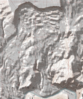
The Hole in the Ground

Turns out that 'All Topo Maps' is pretty easy to use and can generate a nice shaded relief. On a recent map (NBMG Map 156; 30Mb) I experimented with a shaded relief base and it worked pretty well. As an aside, check that map out, but use the right-click, 'save target as' option and then open it up in Acrobat. This map was a real trial and has over 6300 polygons.

In the case of the Owyhee, I will try a similar base, but may tone it down from snippet above. To fully round out the cartographic product, the final colors of the map will be shown in the legend over a clip of shaded relief so that the tonality is not confusing. If you click on the image above (or any image on the blog for that matter) you will see a hi-res example.

Base map update and software of Interest....

The Owyhee River study area base map:

I am formally beginning the process of creating the map and have decided to develop the base map using All Topo Maps v7, a product of iGage software that provides a platform for developing clean and seamless maps using various USGS topographic map products at a range of scales. As soon as the map is generated, I will post a link to it (give me a week or two). The map will be in NAD83, UTM Zone 11 and will have an irregular shape to encompass the relevant map area...actually it will be an inverted 'L' shape given the planform of the river, and may involve two panels. The iGage software also interacts intelligently with GPS units, but doesn't do the handy active downloading of maps, landsat data, and DOQQs that the Topofusion software does.

Goodbye to endnote and procite?

You may also like to know about a very cool Firefox add-on for collecting and managing scientific citations and references of all sorts. This program can quickly and simply extract all relevant bibliographic information from online scientific literature databases (eg., GeoRef, Google Scholar) to store and to generate ref lists for publications. It takes about an hour to figure out. I have already used it in conjunction with UNR library resources to completely research a recent mapping proposal.

Here's a quote from the site (and a link):

'Zotero [zoh-TAIR-oh] is a free, easy-to-use Firefox extension to help you collect, manage, and cite your research sources. It lives right where you do your work — in the web browser itself'

Monday, October 15, 2007

The Grinning Gorilla

This image is from the west cliff of the 'cleft' exposure on the south side of Hole in the Ground, looking to the east side. I think it looks like a gorilla. An interesting question here...are two Bogus Lavas Present? Or are there a series of Greeley advances? There are three palagonite zones present, but the lava cap on the lowest has an erosional cleft that appears to be filled with gravel. There are no palagonites on the west cliff, so it may indicate a relatively long-lived emplacement history of Greeley lavas. Any thoughts?

Birch Creek lava surprises

Back on the May trip, Jim, Kathy, and I traveled to Birch Creek to check out the lava flow relations. Everyone heard about the 'nipple' and the 'tank tread' but most didn't see them. We got some nice pictures, and I have posted some of them here that point out a relation that I did not catch until today. It appears that there are two separate Bogus Lavas here, not simply an eroded single lava. Whoops.
The Nipple: This is an obvious protrusion of lava that appears to be an erosional remnant of the Bogus Rim lava. The surrounding lava flow surface is covered with a veneer of exotic fluvial gravel, but the top of the nipple has no gravel cover. It may actually be that a younger Bogus flow is inset against both sides of the nipple. This seems likely in hindsight, particularly based on relations at the tank tread.


The tank tread was our first glimpse of the interesting cooling pattern of lava lobes(?) in which the columnar structure wraps all the way around the flow and looks like a tank tread. There is a spectacular example of this at Birch Creek. What I didn't notice when there is that the flow exposed on the east side of the ridge is actually a lower (inset?) flow. This relation is very clear on the aerial photos and the topo map.


Slightly more detailed version that also suggests an equivocal QT age for all things Bogus.


Can you teach an old Luddite new tricks?

We'll see how the answer to that one turns out, but I'm game to try, even if it's only as a passive viewer. The blog looks great.--Lisa

Kyle is dragging me into the 21st century

Hi folks - this is a new experiment for me BUT I'm eager to learn. As the lava flow perspective on rivers advances, I'll try to post tidbits (as soon as I figure out how to put photos on I'll post some from the Lava Butte field trip!) Kathy

2007 Field Traverses


This map is a clipped screen shot from Topofusion, a really quick and handy program for placing your gps data onto several possible basemaps. Shown are all of the foot traverses that I made between May 1 and October 10, 2007. There is a striking lack of coverage in the Dogleg Bar area that is compensated somewhat by older (river-trip) recons that are not added to this map yet.

Saturday, October 13, 2007

Who are the Yeehows?

Thanks to Kathy and Cooper for many of these photos.

Owyhee Slideshow 1

This is the first of several slide shows. If you click on a photo of interest, it will take you to the online photo album. I will try to make these include logical/topical photo sets as I organize my photos (and many from Kathy and Cooper).

This is only a test, but it just may work.

This is an official attempt to determine if developing a blog about the Owyhee that can include pictures, maps, and commentary (including commentary from all Yeehows) is a better approach than e-mail and ~semi-annual face to face meetings. I will keep all relevant parties apprised as information is added to this site.

The photo below is actually a sunrise over Bogus Point. It looks like a sunset. Perhaps this portends a similar paradox of successfully coaxing some or all of the group to collaborate in this weakly high tech way. Time will tell. Stay tuned.